D5000 Long-endurance Quadcoper for Smart Surveying and Mapping
The D5000 is a compact, long-endurance multirotor UAV, newly developed to meet civilian needs for high-precision mapping applications.
With a maximum takeoff weight of 4.1 kg, it offers an impressive flight time of up to 90 minutes, showcasing exceptional endurance for long-duration missions. Ideal for tasks such as aerial mapping, infrastructure inspections, and emergency response, the D5000 is engineered to deliver reliable performance and high-quality data in diverse operational environments.
Image Control-Free Topographic Mapping
With a 20 Hz high-precision differential GNSS, the D5000 performs topographic mapping without the need for image control points, ideal for a variety of applications.
Long Endurance, High Efficiency
Offering up to 90 minutes of flight time per sortie, the D5000 maximizes operational efficiency with optimized flight paths.
High Reliability
Equipped with a high-precision GNSS supporting GPS, Beidou, GLONASS, Galileo, QZSS, and 16 frequency bands, the D5000 boasts strong anti-interference capabilities for smooth operation in complex environments like mining sites, bridges, and shipborne platforms. Redundant core modules (IMU, barometer, magnetometer, and GNSS) ensure safety and reliability through rigorous component and system-level testing.
Modular Payload Design & Multisource Data Acquisition
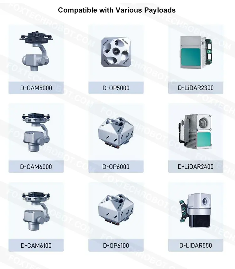
The D5000 supports a range of payloads, including single-head photogrammetry, penta-head oblique, LiDAR, thermal infrared, visible light video, and thermal infrared video modules, along with compatible software for versatile data collection.
Precise Terrain Following
Paired with UAVManager Professional Edition software, the D5000 achieves accurate terrain-following flight, enhancing image quality and maintaining consistent resolution.
Automatic Obstacle Avoidance
The D5000 is equipped with a forward-facing TOF LiDAR module for real-time obstacle detection, improving flight safety.
Comprehensive Software & Advanced Data Processing
UAVManager Professional Edition software provides end-to-end support, including 3D flight planning, real-time monitoring, control point measurement, aerial triangulation, and data processing (DOM, DEM, DSM, TDOM, LiDAR point cloud, etc.).
Cloud-Based Active Service
Leveraging cloud services, the system enables project synchronization, flight data sharing, remote UAV maintenance, real-time flight display, and video streaming via 4G/5G networks.
Your Purchase Includes:
1 x D5000 Quadcoper
1 x D5000 Data Transmission Module
1 x UAVManager Professional Edition (Surveying Version)
2 x D5000 Smart Batteries
1 x D5000 Smart Battery Charger
1 x D5000 Transport Case


-
Icon
Technical Support
Professional & Just-in-time
-
Icon
Product Warranty
6 months
-
Icon
-
Icon
Customization
Personalized


