The Smart Point Cloud Earthwork Measurement Module of the UAVManager Professional Version is Newly Launched
Earthwork volume calculation refers to the engineering volume of excavation, landfill, transportation, stacking, and other operations of earth and rock in construction, road, water conservancy, mining, and other projects. The size of the earthwork is directly related to the investment and progress of the project. Therefore, accurate calculation of earthwork has become an important link in engineering design and construction. There are many traditional earthwork calculation methods, including cross-section method, grid method, contour line method, etc., but these methods require manual measurement and drawing, which is time-consuming and labor-intensive, and are prone to errors and omissions. With the advancement of science and technology, the use of lidar scanning and processing technology for 3D reconstruction and analysis provides a more efficient and economical technical path for earthwork calculation.
If you're interested in UAVManger, please contact us
Earthwork volume calculation refers to the engineering volume of excavation, landfill, transportation, stacking, and other operations of earth and rock in construction, road, water conservancy, mining, and other projects. The size of the earthwork is directly related to the investment and progress of the project. Therefore, accurate calculation of earthwork has become an important link in engineering design and construction. There are many traditional earthwork calculation methods, including cross-section method, grid method, contour line method, etc., but these methods require manual measurement and drawing, which is time-consuming and labor-intensive, and are prone to errors and omissions. With the advancement of science and technology, the use of lidar scanning and processing technology for 3D reconstruction and analysis provides a more efficient and economical technical path for earthwork calculation.
Features
1) Connect the process of UAV LiDAR data acquisition, point cloud calculation, earthwork calculation, result report output, etc., to form an integrated solution of software and hardware.
2) Earthwork calculation and report export can be realized without complicated and frequent operation processes and format conversion processes.
3) It supports the simultaneous calculation of large data volumes, large survey areas, and multi-area earthworks, avoiding repeated settings and multiple calculations.
4) Support multi-step settings, and you can set different step ranges and step sizes according to actual needs, and then calculate the output.
5) Support multiple reference planes and multiple algorithm options, adapting to different terrains and calculation requirements of different scenarios.
6) It supports a 3D simulation display and can perform 360°×360° all-around intuitive browsing and viewing of the calculated filling and excavation volume through the view.
7) Support custom report export.
8) High calculation accuracy and reliable calculation results.
Process
Step 1: Collect lidar data
We provide a variety of air-to-ground LiDAR scanning equipment, including long-range and medium-range LiDAR series suitable for large-area terrain acquisition, short-range LiDAR series suitable for small-area topographic mapping, and hand-held acquisition of complex small areas SLAM100. These products can obtain high-precision point cloud data.
Step 2: Process LiDAR Data
Use UAV manager to preprocess point cloud data such as filtering, registration, and correction, remove noise and abnormal points, improve data quality and accuracy, and then perform segmentation, classification, and feature extraction on point cloud data to identify earthworks Area and other areas, determine the scope of earthwork calculation.
Step 3: Calculating Earthwork Quantities
According to the terrain characteristics and calculation requirements of the earthwork area, the corresponding calculation mode is selected to calculate the earthwork volume within the range.
Step 4: Generate Quantity Report
According to the earthwork calculation results, a detailed earthwork report is generated, which provides block, extent, surface area, projected area, fill volume, cut volume, total volume and thumbnails of the calculated area.
Detailed Description
The earthwork function module is divided into volume calculation and change analysis. The overall module has the following features:
★ Friendly user interface, convenient operation, intuitive display, can directly use the point cloud to calculate the filling and excavation volume, eliminating the intermediate process of establishing triangulation with general software;
★ Wide adaptability to terrain, can calculate the square volume of the bottom surface composed of plane and complex curved surface;
★ There are various algorithms, you can choose the triangular network method and the grid method for calculation according to the data type and terrain characteristics, and the calculation process does not involve the processing and setting of the intermediate file (DTM);
★ Support step range setting, and can calculate the filling and excavation volume of each step;
★ Support the display of filling and excavation volume, and can browse through human-computer interaction;
★ The volume calculation function can support the simultaneous calculation of multiple ranges of earthwork and export multiple calculation reports at the same time;
★ The change analysis function can calculate and analyze the change quantity of two periods.
Volume Calculation Function
(1) Data input on volume calculation function interface
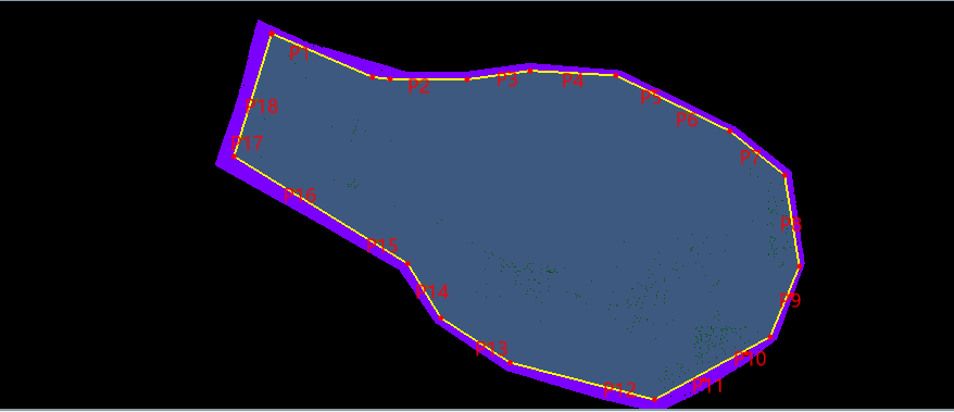
The volume calculation interface includes data addition, setting, result display, calculation area thumbnail display, progress bar and report export functions.
(2) Data input
The data includes [point cloud data] and [range data]. Point cloud data supports checking directly from existing projects or adding additional point cloud data. Range data supports three formats *.fmb\*.shp\*.dxf, which can be manually drawn in the smart point cloud or imported into existing range files. In particular, multiple point cloud data and multiple range data can be input at the same time, and earthwork quantities in multiple ranges can be obtained after calculation.
(3) Bottom type setting
The bottom surface type is divided into plane, fitting plane and complex surface. When selecting a plane, you need to input the value of [Foundation Surface Height], and the software will use the input base surface height value as a benchmark to calculate the filling and excavation volume. When selecting the fitting plane, you need to add the coordinates of the fitting plane. Select the Add Point button, hold down the Ctrl key, and click to add coordinates on the original point cloud, and the coordinates will be displayed in the dialog box. When selecting a complex surface, you need to input DEM data, and the DEM data supports two formats: *.tif and *.tiff.
When the fitting plane is selected, there will be fitting coordinate data display and operation function buttons on the software interface. In the cascade interface, the added fitting coordinate data can be deleted and cleared, and fitting coordinates can be added by manually inputting coordinate values.

(4) Category setting
The category setting can calculate the earthwork volume according to the classification category of the point cloud data. If the point cloud data has no classification, [0-unknown] is selected by default; if the point cloud has classification information, select the required type to calculate.
(5) Calculation method
The calculation method can choose triangular network method or grid method. When the triangular network method is selected, the calculation can be started directly; when the square network method is selected, the grid size needs to be set, and the grid size setting is set according to the accuracy of the original data and the calculation requirements.
(6) Sampling spacing
The sampling interval can be used to set the sampling interval when calculating the earthwork volume. The smaller the sampling interval, the more accurate the volume calculation will be. However, if the sampling interval is too small, the calculation efficiency will deteriorate.
(7) Maximum side length
When the drawn boundary or point cloud boundary is a concave polygon, the volume calculation value will be distorted; the maximum side length is used for concave polygon calculation to obtain an accurate volume. The maximum side length needs to be greater than 2 times the sample size.
(8) Ladder calculation settings
The ladder calculation needs to set the ladder range and the ladder step length, and the software will calculate the fill volume and excavation volume in the ladder datum plane.
(9) Results display
In the [Result] dialog box, the calculation result can be displayed, and the calculation result can be the area, fill volume and excavation volume of one block or multiple blocks. When the step range is checked, the range value and fill and cut volume of each step are displayed.
(10) Results browsing
Place the mouse in the display dialog box on the right to operate the display of the calculation area. Slide the mouse wheel to zoom in or out, press and hold the left button to move to rotate the viewing angle, and hold down the mouse wheel to pan the displayed object.
(11) Report export
Click the [Report] button to export the *.pdf report of earthwork calculation. The report provides block, range, surface area, projected area, filling volume, excavation volume, total volume and thumbnails of the calculation area.
Volume Change Analysis Function
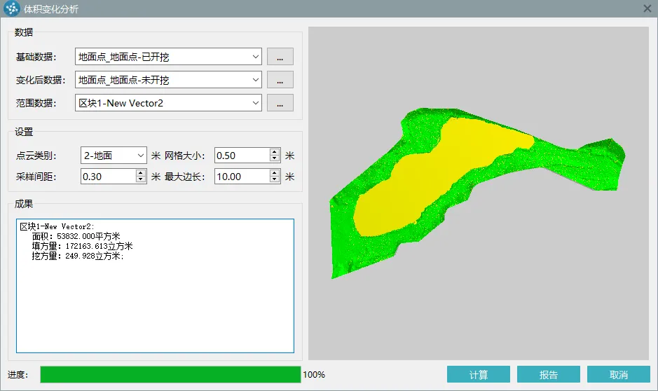
The volume change analysis interface includes data addition, setting, result display, calculation area thumbnail display and report export functions. During volume change analysis, a calculation progress bar is attached.

(1) Data Input
There are three types of data input: [Basic Data], [After Change Data] and [Range Data]. Among them, the formats of [Basic Data] and [After Change Data] are Pegasus inherent *.fmi point cloud data, and the format of [Range Data] supports *.fmb\*.shp\*.dxf. It supports directly selecting the data in the project for processing, or adding additional point cloud data for processing. Range data supports direct manual drawing, or directly importing existing range data.
(2) Calculation settings
The calculation settings need to set the point cloud category, sampling interval, maximum edge length, and grid size.
(3) Result display, result browsing, and report export
These three operations are consistent with volume calculations.
- Reinforcement Learning Enables Bipedal Robot to Conquer Challenging Terrain
- Drones for 3D Indoor Exploration-Cultural Relics Protection and Indoor Survey
- Industry Application: Intelligent Unmanned Operation Solutions for Lakes – Rapid Deployment for Continuous Protection
- High-Altitude Cleaning Case Introduction - Drone Spraying and Cleaning
- New Performance: SLAM Handheld Lidar Scanner + External Panoramic Camera New Combination

